
← Back to North Yukon Change Registry
LMU boundaries have been amended to reflect the future park boundary and all references to “Summit Lake – Bell River” have been amended to Dàadzàii Vàn.
The June 2009 Approved Plan remains the canonical version. No amended version of the plan has been produced.
All references to “Summit Lake – Bell River” in the plan and on the maps are hereby amended to Dàadzàii Vàn. Other references to Summit Lake and Bell River as hydrometric features and surrounding LMUs and sub-units will still be maintained.
Plan Section 4.2.2 (page 4-3) states the following:
The land designation concept for this area would be to create a Protected Area network connecting Whitefish wetlands with Summit Lake – Bell River and the NWT Rat River Gwich’in Conservation Zone (Gwich’in Land Use Planning Board, 2003).
Plan Recommendation: (page 4-4)
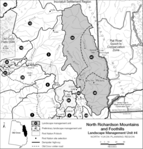
LMU 4C, Summit Lake – Bell River, a sub-unit of the Northern Richardson Mountains and Foothills, should be designated a Protected Area category (see Figure 4-2 for location). This area is centered on Summit Lake-McDougall Pass and the lower Bell River corridor around Lapierre House, including portions of the upper Bell and LaChute river watersheds.
Figure 4-2. Location of LMU 4C, Summit Lake – Bell River, within the Northern Richardson Mountains and foothills landscape management Unit.
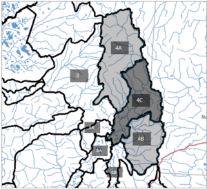
New Boundaries
Implementation Actions:
Land management unit boundaries have been amended to reflect the future park boundary. The Land Management Unit boundaries include:
- 4A Bell – Waters River
- 4B LaChute River
- 4C Summit Lake – Bell River
- 8B Eagle – Bell River
Specific Plan Adjustments
Section Maps
Page(s): Map 1: Land Use Categories and Integrated Management Area Zones
Details:
Rename “Summit Lake – Bell River” to “Dàadzàii Vàn”.
Change boundaries as per above map depiction.
Document Status: Unchanged
Notes:
Section 6.0 Landscape Management Units, unit #8, sub-unit #8B Eagle - Bell River
Page(s): 6-22 and 6-21 (map)
Details:
Boundary changed as per the above map.
Unit is composed of two parts.
The total revised area for this unit is: 1,026 km².
Document Status: Unchanged
Notes:
Section 6.0 Landscape Management Units, unit #4, sub-unit #4C Summit Lake - Bell River
Page(s): 6-12 and 6-11 (map)
Details:
Name change to Dàadzàii Vàn.
Boundary changed as per the above map.
The revised area for this unit is: 1,526 km².
Document Status: Unchanged
Notes:
Section 6.0 Landscape Management Units, unit #4, sub-unit #4B LaChute River
Page(s): 6-12 and 6-11 (map)
Details:
Boundary changed as per the above map.
The revised area for this unit is: 1,287 km².
Document Status: Unchanged
Notes:
Section 6.0 Landscape Management Units, unit #4, subunit #4A Bell - Waters
Page(s): 6-10 and 6-11 (map)
Details:
Boundary changed as per the above map.
The revised area for this unit is: 2,275 km².
Document Status: Unchanged
Notes: