
← Back to Peel Watershed Change Registry
PPIC has agreed to a boundary for a proposed new park requiring a change to the dividing line between LMU 8 & 14.
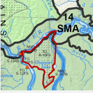
The Peel Plan Implementation Committee has agreed to a boundary for the proposed Teetł’it Gwinjik National Park that requires a change to the dividing line between Landscape Management Units 8 &14.
The protected area includes both LMUs 11 & 14 and TGTC R-10FS which is Tetlit Gwich’in Council Settlement Land. An additional parcel of land adjacent to R10FS is also included in the boundary.
The area shown in red below is to be included in LMU 14.
Specific Plan Adjustments
Section 3.2.1 Conservation Area
Page(s): 36
Details:
The PPIC implementation plan states that:
“YG, FNNND, GTC and Parks Canada have all accepted the recommendation of the Feasibility Assessment, which is to proceed to establishment negotiations. The parties continue to work together towards the establishment of Teetł'it Gwinjik National Park.”
Specific Amendments
In Section 5 of the plan, LMU 14 (Peel River), TGTC R-10FS, and adjacent land, as depicted in the Teetł'it Gwinjik National Park Feasibility Study, are to be combined into one unit.
Map 1 and other related maps will be amended to show the new boundary.
Document Status:
Notes: