← Back to North Yukon Change Registry
Withdrawals from disposition lifted for LMUs: 2A, 2B, 2C, 3, 4A, and 8B.
The recommendation in section 4.4 of the Plan states:
Should the applicable authorities decide to lift the North Yukon Land Withdrawal at a future date, LMU 2A (Old Crow – Rampart House, LMU 3 (Driftwood River), and LMU 4A (Bell – Waters River) should be considered for Integrated Management Area Zone II designation.
In 2010, the Parties agreed to make these changes in concert with a consultation plan.
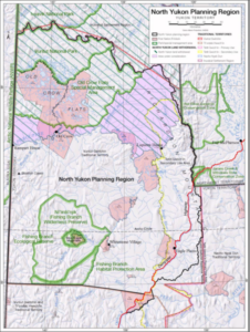
Figure 2.1 North Yukon Planning Region:
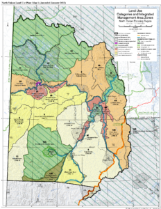
2012 map showing the lifting of the withdrawal:
Specific Plan Adjustments
Section 2.1 Setting
Page(s): 2-1
Details:
The last paragraph of p. 2-1 should be updated as follows:
Original Text:
The North Yukon Land Withdrawal, an area that has not been available for land disposition and resource exploration since 1978, affects lands north of the Porcupine and west of the Bell rivers.
New Text:
The North Yukon Land Withdrawal was originally established in 1978 and replaced at the time of devolution to Yukon Government in 2003. Subsequent to North Yukon Plan Approval, new withdrawals were put into place that applied to the Yukon North Slope, Ivvavik and Vuntut National Parks, Old Crow Flats, Whitefish Wetlands, and Summit Lake – Bell River areas. Withdrawn lands were lifted in the remaining portion of the original North Yukon Land Withdrawal. The areas no longer under withdrawal include LMUs: 3, 4A, and 8B.
Document Status: Unchanged
Notes:
In August 2026, the oil and gas and mineral withdrawals of the Old Crow Flats Reminder area were renewed for a 10-year term, ending August 2036.
Section 2.1 Setting
Page(s): 2-2 (Figure 2.1: North Yukon Planning Region Map)
Details:
Figure 2.1 modifications as follows:
- Change legend to reflect that green cross-hatches are North Slope Land Withdrawal.
- Change boundary of cross-hatched area to reflect the North Slope watershed boundary. It no longer applies to the Ivvavik and Vuntut National Parks, nor Old Crow Flats.
Document Status: Unchanged
Notes:
2012 map was produced showing the lifting of the withdrawal.
Section 4.4 North Yukon Land Withdrawal
Page(s): 4-5, 4-6
Details:
Section 4.4 should be updated as follows:
Original Text
The North Yukon Land Withdrawal was established in 1978 during negotiation of the Inuvialuit Final Agreement, and has no specific term. Within the planning region, the land withdrawal applies to all lands north of the Porcupine and west of the Bell rivers, affecting 12% of the planning region. These lands are not available for mineral and oil and gas disposition and exploration.
The Parties to the Plan, the Yukon and Vuntut Gwitchin governments, requested that the NYPC provide land use designation recommendations for the area affected by the land withdrawal. These recommendations do not represent a proposal by NYPC to lift the land withdrawal. Rather, the following recommendation provides land use designations for consideration should the applicable authorities decide to lift the land withdrawal at a future date. Several governments and land claim boards/committees have management responsibilities and interests in the withdrawal area. A portion of the land withdrawal area, Summit Lake – Bell River (LMU 4C), has been recommended for Protected Area designation by this Plan (see 4.2.2, above).
Key issues with respect to the status of the land withdrawal include:
• The area contains some of the highest wildlife, fish, cultural, and heritage values in the region, including important concentrated use areas for the Porcupine caribou herd;
• Adjacent lands in the Arctic National Wildlife Refuge, Yukon North Slope and Gwich’in Settlement Region have a strong conservation management focus; and,
• The area is not currently available for rights issuance or non-renewable resource land uses, potentially impacting future economic opportunities in the region.
New Text
The North Yukon Land Withdrawal was established in 1978 during negotiation of the Inuvialuit Final Agreement, and had no specific term. Within the planning region, the land withdrawal applied to all lands north of the Porcupine and west of the Bell rivers, affecting 12% of the planning region. These lands were not available for mineral and oil and gas disposition and exploration.
In 2010, subsequent to North Yukon Plan Approval, new withdrawals were put into place that applied to the Yukon North Slope, Ivvavik and Vuntut National Parks, Old Crow Flats, Whitefish Wetlands, and Summit Lake – Bell River areas. Withdrawn lands were lifted in the remaining portion of the original North Yukon Land Withdrawal. The areas no longer withdrawn from mineral and oil and gas disposition include LMUs: 3, 4A, and 8B. Designation of those LMUs are set out in Section 6.
Key issues with respect to the status of the land withdrawal include:
• The area contains some of the highest wildlife, fish, cultural, and heritage values in the region, including important concentrated use areas for the Porcupine caribou herd; and
• Adjacent lands in the Arctic National Wildlife Refuge, Yukon North Slope and Gwich’in Settlement Region have a strong conservation management focus.
Document Status: Unchanged
Notes:
Section 4.4 North Yukon Land Withdrawal
Page(s): 4-6, A2-8
Details:
Recommendation to be deleted:
RECOMMENDATION: Should the applicable authorities decide to lift the North Yukon Land Withdrawal at a future date, LMU 2A (Old Crow – Rampart House, LMU 3 (Driftwood River), and LMU 4A (Bell – Waters River) should be considered for Integrated Management Area Zone II designation.
Document Status: Unchanged
Notes:
This recommendation is no longer required, given the changes that have been implemented.
Section Appendix 1
Page(s): Map 1 (Land Use Categories and Integrated Management Area Zones)
Details:
Map 1 modifications as follows:
- Change legend to reflect that green cross-hatches are North Slope Land Withdrawal.
- Change boundary of cross-hatched area to reflect the North Slope watershed boundary. It no longer applies to the Ivvavik and Vuntut National Parks, nor Old Crow Flats.
Document Status: Unchanged
Notes:
2012 map was produced showing the lifting of the withdrawal.