PEEL WATERSHED PLANNING REGION:
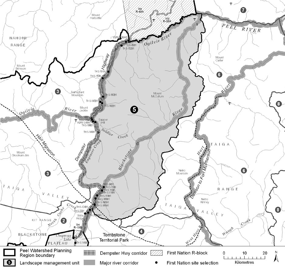
LMU 5: Blackstone River
Land Use Designation
Integrated Management Area, Zone III
Land Status
Non-Settlement Land, TH Settlement Land (R-35B)
Traditional Territories
Tr’ondëk Hwëch’in, Na-Cho Nyäk Dun, Vuntut Gwitchin, Tetłit Gwich’in Secondary Use Area
Area
3,588 km2 (5% of Region)
Objectives
- Ecological integrity is maintained.
- Some culturally and ecologically-aware resource exploration and extraction that supports the local economies.
- All permitted land use activity does not significantly impact movement and habitats of caribou.
- Continued use of the Blackstone River for accessible wilderness tourism.
Rationale for Designation
- Adjacency to the Dempster Highway may allow development to occur more readily with less access-related impacts.
- Existing tourism and recreation opportunities are generally reliant on Dempster Highway, and may be somewhat more tolerant of development than in more remote areas.
- Flatter areas of unit makes cumulative effects monitoring more effective in limiting impacts on habitat in those area; however,
- Most of the unit is quite rugged, thus limiting the effectiveness of cumulative effects monitoring; and,
- The high value of this unit for the Porcupine caribou herd, Dall’s sheep, and the people that hunt them calls for a limited scale of industrial development, thus meriting a Zone III designation.
Cumulative Effects Thresholds
Relative to LMU Size*
Surface Disturbance (%)
Linear Density (km/km2)
Current disturbance (2020)
0.153
0.0914
Cautionary
0.375
0.375
Critical
0.500
0.500
On the ground amounts**
Surface Disturbance (km2)
Linear Disturbance (km)
Current disturbance (2020)
5.49
328.1
Room under cautionary threshold***
7.97
1,017.36
Cautionary
13.45
1,345.5
Critical
17.94
1794.0
*These are proportional to the size of the LMU, and correspond to table 3-2 of the Approved Plan. They are measured in the % of the LMU that can be disturbed (“Surface Disturbance”) and in km/km2 (“Linear Disturbance Density”).
**These are amounts that can be measured and apply to the whole LMU and would be more familiar to project proponents and regulators. They are measured in km2 of disturbance and in km of linear disturbance (e.g., roads, trails and cutlines).
***How much more disturbance can be added to existing disturbance before the cautionary threshold is reached.
Cumulative Effects Indicators
Surface Disturbance
Linear Disturbance
Cautionary
Critical
Biophysical Setting
Setting
Generally mountainous terrain with forested valley bottoms, slopes and flats.
Ecoregions
North Ogilvie Mountains
Bioclimatic Zones
Taiga Wooded, Taiga Shrub and Alpine
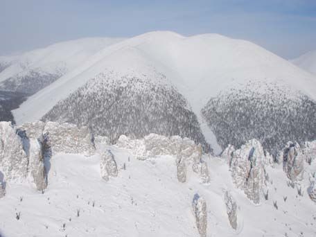
Image Explanation
Weathering and lack of glaciation and have resulted in pillars of rocks called tors. Deep forested valleys are also characteristic of this area. (YG photo)
Ecological Resources
Caribou
High value winter habitat of the Hart River herd concentrated along forested valley bottoms and flatter terrain. Moderate value winter habitat of the Porcupine herd throughout. The Porcupine herd has general use winter and fall areas scattered throughout this unit.
Moose
Narrow bands of high habitat suitability along smaller tributaries; generally low late winter habitat suitability elsewhere.
Marten
Generally poor quality winter habitat; significant pockets of moderate habitat occur.
Sheep
Extensive areas of highly suitable winter habitat with documented (TK, big game outfitters, scientific) habitat use. Scattered licks.
Fish
Winter overflow, open water and surface groundwater locations indicate overwintering potential, fish in rivers and lower gradient tributaries.
Grizzly Bear
Mostly moderate habitat suitability in low to mid elev.; high in riparian areas and subalpine zones.
Peregrine Falcon
High potential for peregrine falcon foraging and nesting habitat in lower elevations.
Birds (General)
High value waterbird habitat in riparian areas; low to moderate breeding bird species richness; moderate number species of conservation concern.
Vegetation
High endemism/rarity. Alpine plants, low-mid elevation dry herb/shrub/coniferous forests, mid-subalpine shrub, riparian communities.
Wetlands, Lakes and Riparian Areas
Few small wetlands. Narrow riparian strips.
Permafrost
Extensive high water content permafrost expected for flatter pediments/plateaus.
Special Features
Some mineral licks. Several possible wildlife passes.
Heritage, Social and Cultural Resources
Heritage Resources
Cabins (TH) and camps (NND). Culturally important places for TGFN, TH, VGFN. Several heritage routes.
Palaeontological Resources
The Bouvette Formation; Road River Group: Ogilvie Formation and Michelle Formation sedimentary rocks in this area have known fossil localities and have high potential to yield further discoveries.
Economic Development
Transportation and Access
The Dempster Highway lies at the western boundary. A few airstrips of unknown status along highway and near mouth of the Blackstone River.
Traditional Economy
Significant harvesting along Dempster Highway. Other traditional harvesting and wildlife area and big game/fur-bearing locations.
Recreation and Tourism
Near the Dempster Highway there are front-country tourism opportunities. Blackstone River provides as readily accessible “backcountry” paddling experience.
Forestry
Little potential for forestry.
Big Game Outfitters and Trapping
Blackstone Outfitting Ltd.; some high value hunting.
Oil and Gas Resources
No potential.
Mineral Resources
Approximately 193 (2023, 340 in 2011) quartz claims; moderate zinc-lead potential; moderate-high general mineral potential.
Special Management Considerations
- The proposed right-of-way for the Dempster Highway lateral pipeline runs along western boundary.
- Major River Corridor management directions apply along the Ogilvie and Blackstone Rivers.
- Dempster Corridor management directions apply near the Dempster Highway.
- Subsequent Dempster Highway land use plan may apply near the Dempster Highway.
- The administrative boundary between NND and TH traditional territories runs through NE corner.
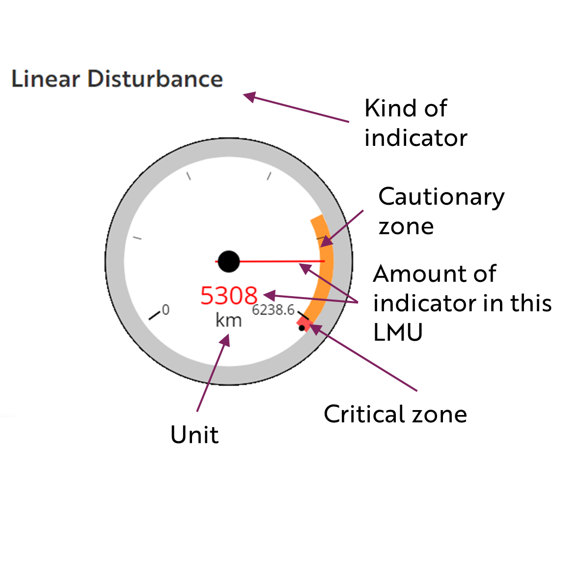
These gauges show how much of each disturbance indicator there is in the LMU with the needle and the large number near the middle. The colours indicate disturbance level zones or thresholds. If the needle is in the white zone, no threshold has been reached.
The Dawson Planning Commission gives a details of their similar (but slightly different) Cumulative Effects Framework on their website.
Cautionary
Critical
