PEEL WATERSHED PLANNING REGION:

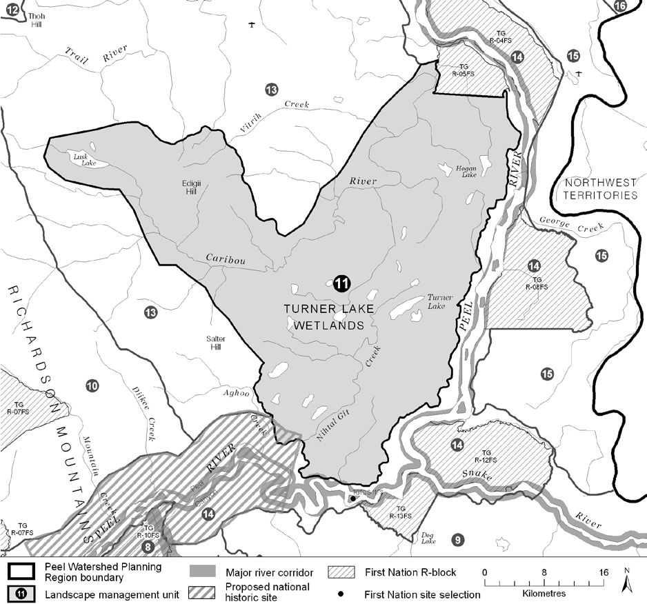
LMU 11: Turner Lake Wetlands and Caribou River
Land Use Designation
Special Management Area
Land Status
Non-Settlement Land
Traditional Territories
Na-Cho Nyäk Dun, Tetłit Gwich’in Primary Use Area
Area
1,611 km2 (2% of Region)

Implementation News

  • Much of this LMU and LMU 14 are being considered to be in a new national park. The First Nation of Na-Cho Nyäk Dun and the Gwich’in Tribal Council would co-develop and co-manage this park together with Parks Canada. If established, this proposed park would permanently protect 3,000 square kilometres. See this press release for more information.
Objectives

  • Water quality and flow in Lusk Lake, the Turner Lake wetlands and the Caribou River are not affected by  human activities.
  • Community cultural activities practiced without significant disturbance.
  • The ecological and cultural significance of Edigii Hill (aka Caribou Mtn) remains undiminished.
  • Wilderness character is maintained.

Rationale for Designation

  • Includes a Yukon Key Wetland complex that is a well situated stop over for migrating waterfowl.
  • Highest concentration of lakes and wetland complexes in the Region.
  • Highly valued for trapping and other cultural activities.
  • Edigii Hill (or, Caribou Mountain) and Lusk Lake are culturally important places for the TG.
  • Traditional Knowledge indicates that Edigii Hill has been used an alternate calving ground for the Porcupine Caribou Herd. It could be a significant feature during other stages.
  • Several traditional travel routes traverse the unit.
  • Both Edigii Hill and the Turner Lake wetlands were recommended for consideration for protection by the Peel River Watershed Advisory Committee.
  • The steep escarpments that overlook the Caribou River are underlain with permafrost and therefore are especially susceptible to surface disturbance. This susceptibility is predicted to increase as a result of climate change. Resulting slope failures could result in hydrological changes catastrophic to the wetlands.
  • Low mineral potential, and moderate oil and gas potential. Difficult access into the area makes resource development more challenging.

Cumulative Effects Thresholds

Relative to LMU Size*
Surface Disturbance (%)
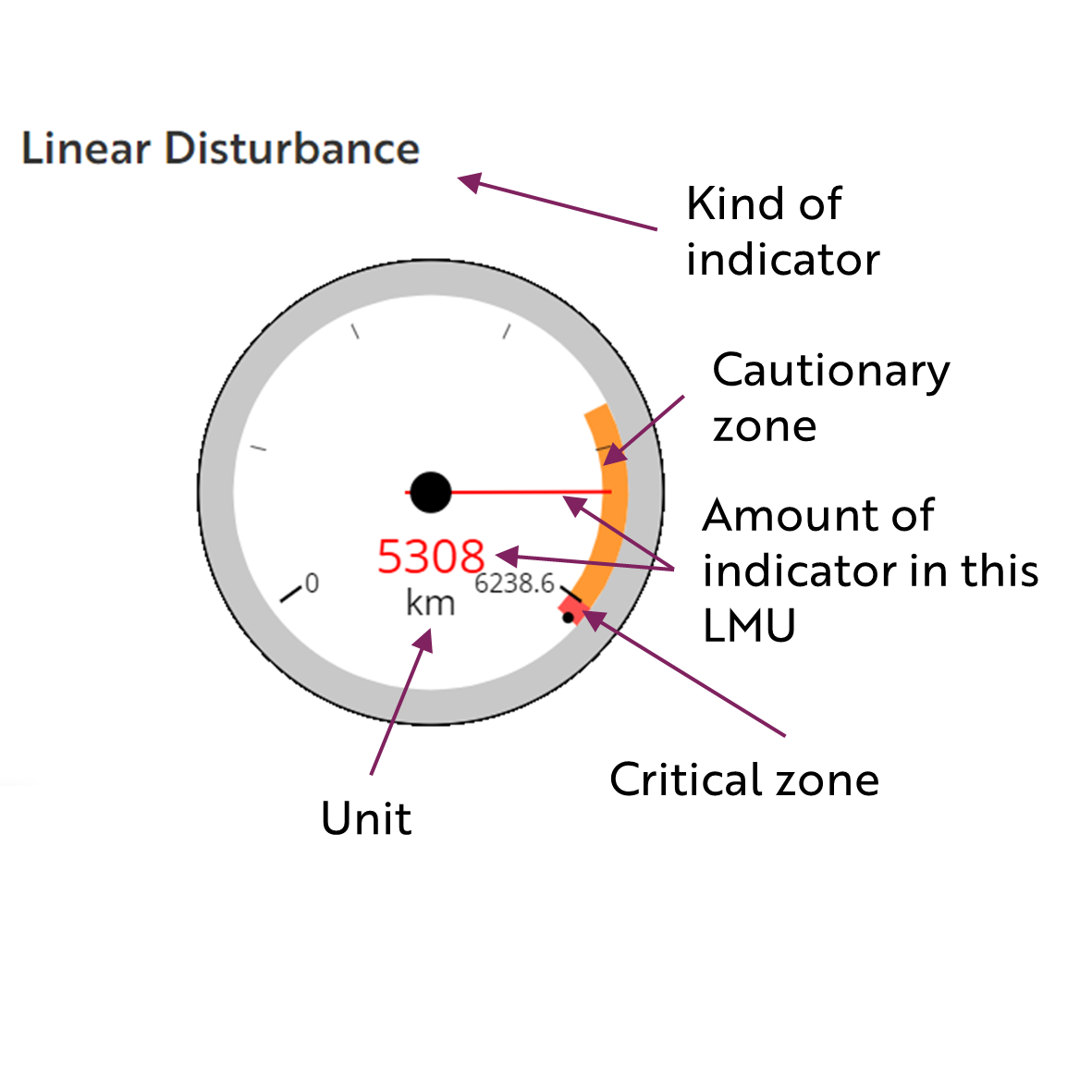
Linear Density (km/km2)
Current disturbance (2020)
0.3756
0.4114
Cautionary
0.0
0.0
Critical
0.0
0.0
On the ground amounts**
Surface Disturbance (km2)
Linear Disturbance (km)
Current disturbance (2020)
6.05
662.8
Room under cautionary threshold***
0
0
Cautionary
0
0
Critical
0
0
*These are proportional to the size of the LMU, and correspond to table 3-2 of the Approved Plan. They are measured in the % of the LMU that can be disturbed (“Surface Disturbance”) and in km/km2 (“Linear Disturbance Density”).
**These are amounts that can be measured and apply to the whole LMU and would be more familiar to project proponents and regulators. They are measured in km2 of disturbance and in km of linear disturbance (e.g., roads, trails and cutlines).
***How much more disturbance can be added to existing disturbance before the cautionary threshold is reached.

Amount of disturbance relative to the cautionary theshold:

%

Surface Disturbance

%

Linear Disturbance

Biophysical Setting

Setting
Flat wetland complex, a large incised river fed by a large lake, and a broad flat hill rising out of the plateau
Ecoregions
Peel River Plateau
Bioclimatic Zones
Taiga Wooded and Taiga Shrub
Image Explanation
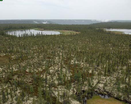
Scattered lakes, wetlands and open forests underlain with lichens and permafrost are throughout this unit. The incised Caribou River valley is in the background. (CWS photo)

Ecological Resources

Caribou
Virtually entire area is moderate and high habitat potential for the Porcupine herd, with concentrations of high potential around central lakes. Little use in recent decades though traditional and scientific knowledge indicate historical heavy use. Edigii hill could be a significant refuge from insects or deep/hard snow pack.
Moose
Expansive moderate-low value late winter habitat.
Marten
Extensive and concentrated moderate to high winter habitat suitability. A culturally-significant trapping area.
Sheep
No sheep habitat.
Fish
Fish presence likely throughout; several known spawning locations.
Grizzly Bear
Low habitat suitability in wetlands, moderate to high towards Richardson foothills.
Peregrine Falcon
Significant peregrine falcon foraging and nesting habitat.
Birds (General)
High concentration of waterbird habitat; high breeding species richness and moderate species of conservation concern.
Vegetation
Low-mid elev. wet herb/shrub/conifer, lichen and dry coniferous forest.
Wetlands, Lakes and Riparian Areas
Highest concentration of lakes and wetland complexes in the PWPR; wetland key area (YG) and territorially significant. Narrow riparian strip along Caribou River
Permafrost
Extensive high water content permafrost expected. Wetlands “perched” above incised valleys and stable slopes rely on intact permafrost.
Special Features
Some mineral licks. Several possible wildlife passes.

Heritage, Social and Cultural Resources

Heritage Resources
Travel route along Caribou River with connectivity to Lusk Lake and Upper Peel River; Connecting routes between Trail River and Mountain Creek to lower Peel River. A few cabins and several culturally important places (TG).
Palaeontological Resources
The sedimentary rocks in this area have high potential to yield Mesozoic fossils.

Economic Development

Transportation and Access
Extensive network of old winter roads and unclassified linear features; a conceptual access route has been identified in this unit from Road River to the Peel River.
Traditional Economy
TG traditional harvesting and wildlife areas. Turner Lake wetlands are known for good trapping.
Recreation and Tourism
No identified high recreation values.
Forestry
Little potential for forestry.
Big Game Outfitters and Trapping
No registered concessions.
Oil and Gas Resources
Peel Plateau and Plain basin and is moderate potential; four abandoned wells. Oil and gas permit (#0018).
Mineral Resources
Generally low mineral potential.

Special Management Considerations

None
Contact YLUPC:
Tel: (867) 667-7397
Email: ylupc@planyukon.ca

Copyright 2023
Yukon Land Use Planning Council

Site Designed by
First Contact Web Design