PEEL WATERSHED PLANNING REGION:

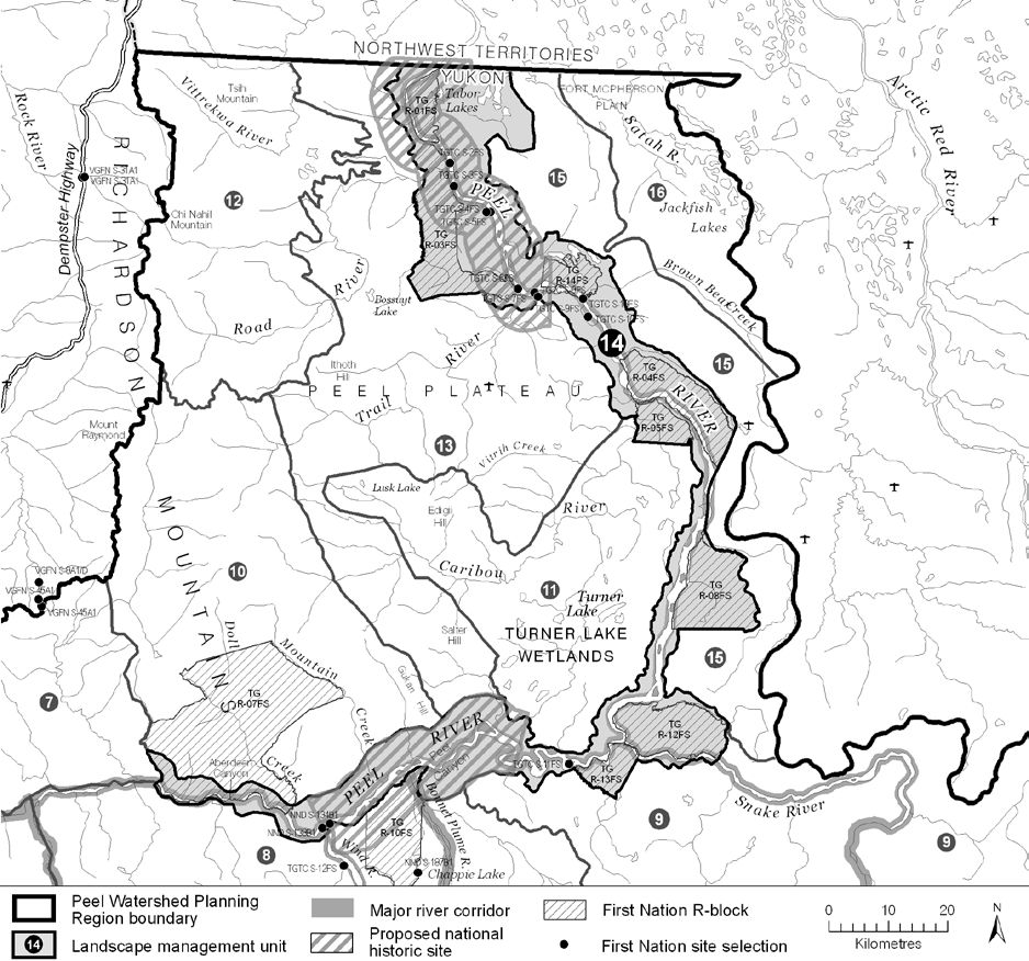
LMU 14: Peel River
Land Use Designation
Special Management Area
Land Status
Non-Settlement Land, NND Settlement Land (S-134B), TG Yukon Land (R-01FS, R-03FS, R-04FS, R-05FS, R-08FS, R-12FS, R-13FS, R-14FS, S-2FS, S-3FS, S-4FS, S-6FS, S-7FS, S-8FS, S-9FS, S-10FS, S-11FS)
Traditional Territories
Na-Cho Nyäk Dun, Tetłit Gwich’in Primary Use Area
Area
2,334 km2 (3% of Region)

Implementation News

Much of this LMU and LMU 11 are being considered to be in a new national park. The First Nation of Na-Cho Nyäk Dun and the Gwich’in Tribal Council would co-develop and co-manage this park together with Parks Canada. If established, this proposed park would permanently protect 3,000 square kilometres. See this press release for more information.
Objectives

  • Wilderness character is maintained.
  • Community cultural activities practiced without significant disturbance.
  • Regionally significant spawning and fish overwintering habitat maintained.
  • Wilderness and cultural tourism activities linked to large tributaries that are consistent with the objectives above.

Rationale for Designation

  • The Gwich’in Social and Cultural Institute nominated two large portions of this unit (Tshuu tr’adaojìich’uu and Teetl’it njik) to be National Historic Sites, in recognition of their great cultural importance to the Tetłit Gwich’in (Heart of the Tetłit Gwich’in Cultural Landscape)
  • Large segments of this unit are Tetłit Gwich’in Yukon Lands (fee simple land held by the Tetłit Gwich’in) that were originally selected because of their cultural importance and proximity to significant wildlife and fish resources.
  • Numerous culturally important places for the Tetłit Gwich’in.
  • Extensively used for subsistence hunting and fishing.
  • Wilderness and cultural tourism corridor.
  • The Peel Watershed Advisory Committee suggested that Aberdeen Canyon and the Peel Canyon be considered for protection.
  • Important spawning habitat for culturally important species.
  • Extensive foraging and nesting habitat for Peregrine Falcons.
  • Medium mineral potential, and moderate oil and gas potential.

Cumulative Effects Thresholds

Relative to LMU Size*
Surface Disturbance (%)
Linear Density (km/km2)
Current disturbance (2020)
0.1552
0.1801
Cautionary
0
0
Critical
0
0
On the ground amounts**
Surface Disturbance (km2)
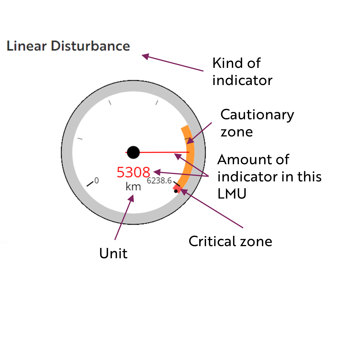
Linear Disturbance (km)
Current disturbance (2020)
3.62
420.4
Room under cautionary threshold***
0
0
Cautionary
0
0
Critical
0
0
*These are proportional to the size of the LMU, and correspond to table 3-2 of the Approved Plan. They are measured in the % of the LMU that can be disturbed (“Surface Disturbance”) and in km/km2 (“Linear Disturbance Density”).
**These are amounts that can be measured and apply to the whole LMU and would be more familiar to project proponents and regulators. They are measured in km2 of disturbance and in km of linear disturbance (e.g., roads, trails and cutlines).
***How much more disturbance can be added to existing disturbance before the cautionary threshold is reached.

Cumulative Effects Indicators

Surface Disturbance

Linear Disturbance

?
Cautionary
Critical

Biophysical Setting

Setting
Broad alluvial flats of the Peel River, adjacent banks and plateau. Two significant canyons (Aberdeen and Peel), several confluences with large tributaries.
Ecoregions
Primarily Peel River Plateau
Bioclimatic Zones
Taiga Wooded
Image Explanation
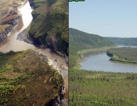
The dramatic Aberdeen Canyon (left) (DFO). Riparian forests and wetlands and often steep escarpments line the Peel River (right) (CWS photo).

Ecological Resources

Caribou
Variable habitat suitability for the Porcupine herd, and moderate to high habitat suitability for the Boreal herd. At the periphery of the ranges of the Porcupine, Boreal and Bonnet Plume populations.
Moose
Extensive moderate valued late winter habitat with pockets of high value habitat along the Peel River. Traditional place to hunt moose.
Marten
Generally moderate value winter habitat.
Sheep
No sheep habitat.
Fish
Fish present throughout, several known spawning locations, sea-run fish spawning throughout; a few winter open water sites; winter surface groundwater throughout.
Grizzly Bear
Variable habitat suitability, highest at river confluences and riparian areas.
Peregrine Falcon
Very high peregrine foraging and nesting habitat along Peel River.
Birds (General)
Moderate waterbird habitat; low to mod breeding spp. richness and species of conservation concern.
Vegetation
Low-mid elev. dry/wet herb and shrub and coniferous forest.
Wetlands, Lakes and Riparian Areas
Wetland complexes along Peel River and confluences. Tabor Lakes are a Yukon Key Wetlands.
Permafrost
Extensive high water content permafrost expected. Wetlands “perched” above escarpments; stable slopes rely on intact permafrost.
Special Features
Peel Canyon; Aberdeen Canyon, Ezhinakàn (Burning Rock).

Heritage, Social and Cultural Resources

Heritage Resources
This unit has extensive cultural value to the Tetł’it Gwich’in. High concentration of VG and TG culturally important places; several cabins identified. Several travel routes. Highest concentration of VG and TG archaeological sites.
Palaeontological Resources
Sedimentary rocks in this area have known invertebrate fossil localities and have high potential to yield further discoveries.

Economic Development

Transportation and Access
The Peel River itself is a well used route, for both summer travel (river boats, historically barges) and winter travel. Many old winter roads; a conceptual access route has been identified in this unit downstream of the Bonnet Plume River confluence with the Peel River.
Traditional Economy
Many fishing locations, big game/fur-bearer locations; TG traditional harvesting and wildlife areas and seasonal land use.
Recreation and Tourism
High value wilderness paddling.
Forestry
Potential localized demand for fuel wood, logs for cabins.
Big Game Outfitters and Trapping
No registered concessions.
Oil and Gas Resources
Peel Plateau and Plain basin; moderate below above the Snake River, low above; three abandoned wells.
Mineral Resources
Medium mineral potential; some coal potential. Approximately 20 quartz claims (2023 and in 2011).

Special Management Considerations

None
Contact YLUPC:
Tel: (867) 667-7397
Email: ylupc@planyukon.ca

Copyright 2023
Yukon Land Use Planning Council

Site Designed by
First Contact Web Design