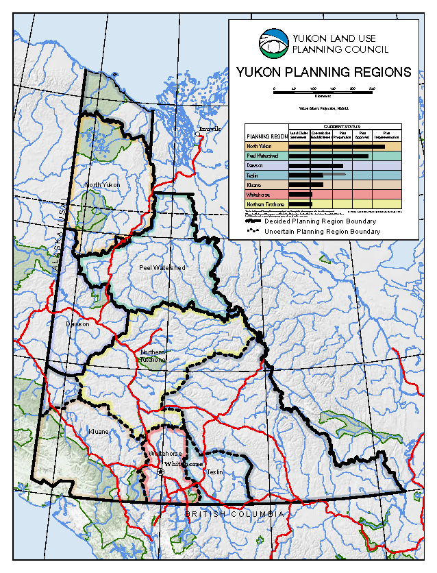
 Land use planning regions are based, where practicable, on the Traditional Territories (TT) of First Nations, or groups of First Nations. There are 7 proposed or accepted planning regions in the Yukon:
- North Yukon (Vuntut Gwitchin TT) – accepted
- the Peel River Watershed (Watershed-based, several TTs) – accepted
- Dawson (Tr’ondëk Hwëch’in) – accepted
- Northern Tutchone (Na-cho Nyak Dun, Little Salmon Carmacks and Selkirk TT) – proposed
- Teslin (Teslin Tlingit TT) – proposed
- Whitehorse (Kwanlin Dun, Ta’an Kwäch’än and Carcross Tagish TT) – proposed
- Kluane (Kluane and Champagne & Aishihik TT) – proposed*
Regional planning cannot proceed in the Kaska region (Ross River Dena and Liard First Nation TT) because of unsettled land claims. Similarly, regional planning as envisioned in the Yukon Final Agreements will not occur in the White River Core Area. White River First Nation does not have a Final Agreement.
The council made several recommendations in September 2011 regarding the planning regions in southern Yukon and has made a few revisions since then. The general configuration recommended plus revisions up to May of 2018 is shown to the right. Click here to download a letter-sized version.
Regional Planning Commissions
A Regional Land Use Planning Commission (RLUPC) is a non-government body mandated under Chapter 11 of a Yukon First Nation Final Agreement. The Commission is responsible for developing a land use plan to recommend to the Government of Yukon and the affected First Nation(s). Commission members are nominated either the Yukon Government or by the First Nation(s) in whose Traditional Territory the planning region is located. A Commission usually has 6 members, consisting of the following:
- 1/3 nominated by Governments
- 1/3 nominated by First Nation(s)
- 1/3 nominated by either or both Governments and First Nation(s), depending on the demographic ratio of First Nation to non-First Nation residents of the planning region.
Commission members are appointed by the Yukon Minister of Energy, Mines and Resources.
